Topographic rise
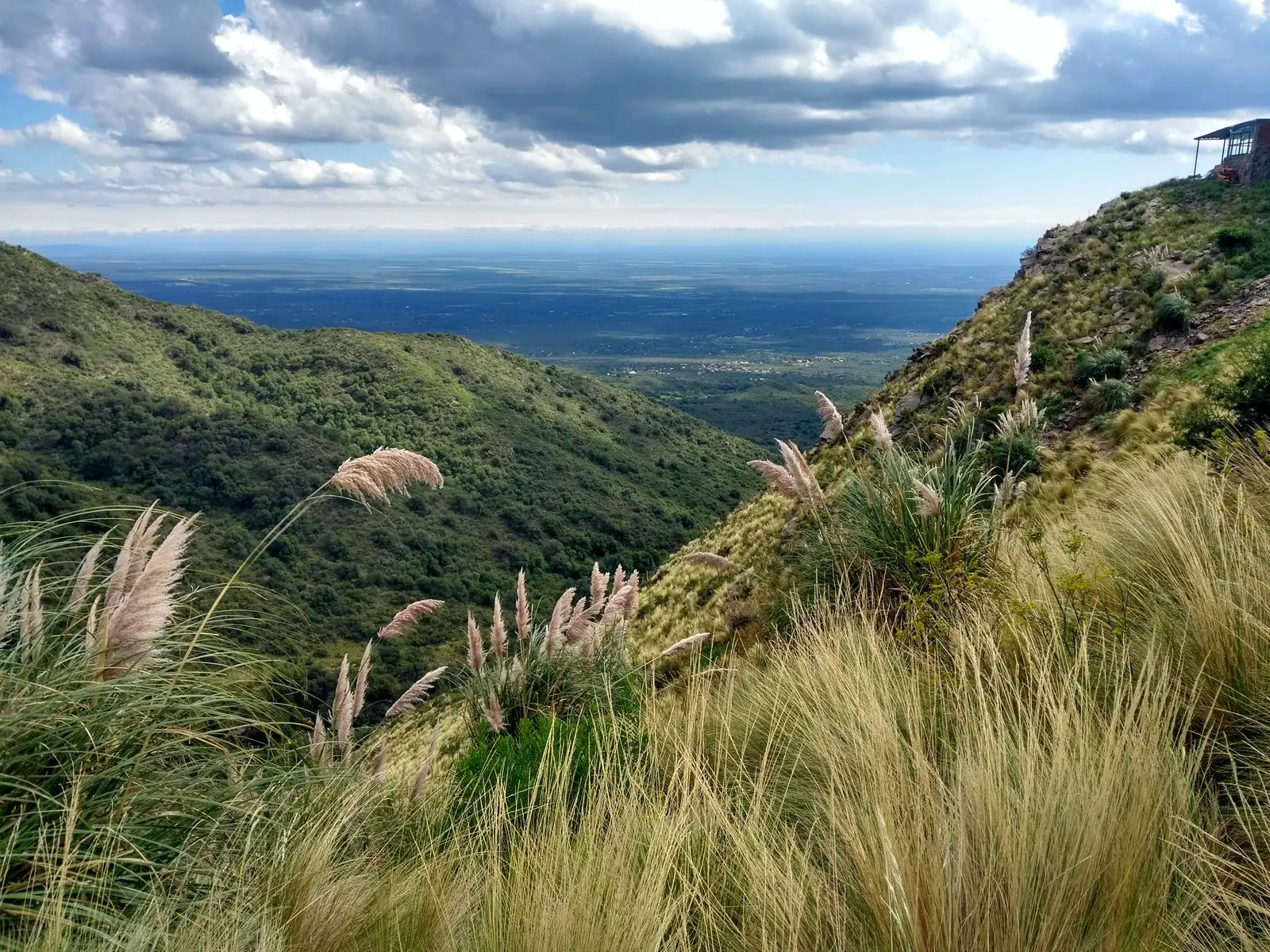
From central Merlo, the road climbs quickly toward the eastern ridge. That rapid gain in elevation explains the widening views, stronger wind, and changing sky conditions often associated with the site.
This page treats the site as a place-based guide rather than a tourism advertisement. It brings together mountain context, microclimate clues, access routes, on-site images, and practical advice for visitors heading above Villa de Merlo.
Key facts
The value of Mirador del Sol comes from more than one activity. Road ascent, elevation gain, valley views, cloud behavior, and local naming traditions all shape the experience.
From central Merlo, the road climbs quickly toward the eastern ridge. That rapid gain in elevation explains the widening views, stronger wind, and changing sky conditions often associated with the site.
Merlo is often described through its local microclimate. At this lookout, visitors mostly notice it through mountain shelter effects, day-night temperature contrast, and inversion layers that can produce morning cloud seas.
The name Mirador del Sol belongs to a broader ridge-view tradition linked to the Comechingones landscape. Sun angles, horizon lines, and seasonal light remain central to the site's identity.
History
To understand Tirolesa Mirador Del Sol, it helps to place it on a longer timeline: Indigenous mountain life, colonial settlement on the lower slopes, Merlo's restorative-town tradition, and the scenic-road culture of the modern era.
Long before Spanish arrival, the Comechingones peoples lived across the mountains and valleys between present-day San Luis and Córdoba. They settled along the ranges, combining gathering, hunting and small-scale farming, and read the land through ridgelines, water sources and the position of the sun. The ridge beneath today's lookout belongs to that long-used cultural landscape.
From the 16th century, Spanish colonial expansion moved up the valleys, bringing ranches, staging posts and mission outposts to the lower slopes. In the mid-19th century Villa de Merlo was formally established and gradually grew into an inland town known for its mountain climate and restorative setting. The road toward the ridge is a product of that link between settlement and highland.
In the later 20th century, as roads were extended and car travel spread, Ruta 5 (Camino al Filo) became the main link from town to ridge. Thanks to its natural high point, Mirador del Sol was gradually established as a public viewpoint for sunrise, cloud seas and valley light — which is also where its modern meaning as a 'sun lookout' comes from.
History
The following belongs to local oral tradition and folklore rather than verifiable history, yet it explains why this ridge holds a special place in the local imagination.
Local oral tradition calls the spot the lookout of the sun. One account holds that early herders climbed the ridge before dawn and read the day's wind and grazing direction from where the sun broke over the valley, gradually establishing a fixed lookout point. The 'Sol' in the name comes from this everyday experience of light and direction.
In stories told around the Merlo valley, the morning cloud sea is imagined as a still white lake, with the ridge resting on it like a moored boat. Elders would warn children not to climb alone when fog crept over the road — the mountain, they said, was speaking through the mist. Such narratives are still used to remind visitors how quickly mountain weather can change.
Merlo's well-known Avenida de los Césares takes its name from the colonial legend of the Ciudad de los Césares, a fabled wealthy city said to lie hidden in the southern mountains. The story was never verified, yet it shaped this range's imagination of the unknown — and it is a useful reminder that what is truly worth seeking here is the geology, the night sky and the clouds themselves.
Weather
The data below updates according to the lookout's coordinates, helping you decide whether to carry rain and warm layers and how to time the ascent.
Loading weather data…
Loading weather data…
The lookout sits at about 1,470 m, usually 4–6°C cooler than central Merlo and exposed to noticeable ridge wind.
Photos
The gallery uses local images of the valley, mountain road, lookout area, and activity setting, offering a visual reference before arrival. The hero background comes from the same on-site image set.


Overview
Read as a field site rather than a simple stop, the lookout reveals useful clues about mountain ecology, zipline physics, and the timing of light.
As the road rises, lower dry woodland gives way to wind-tolerant shrubs, grasses, and exposed rock. The ridge also creates good conditions for observing soaring birds using thermal and slope lift.
Mountain ziplines rely on elevation difference and cable tension. Wind, body weight, and daily operating conditions all affect speed and comfort, so the operator's current briefing should always take priority.
Morning is often better for cloud layers and inversion effects, while late afternoon is stronger for side light on the ridge. For photography, timing matters as much as a clear forecast.
The ride uses a harness, helmet and a pulley system on a steel cable, with a briefing and specialist guides. Equipment and protocols are checked before each departure, and the final go/no-go decision rests with the on-site team according to wind, visibility and rain.
Key facts
A stronger destination page benefits from a compact technical sheet summarizing coordinates, elevation, rock type, climate, and vegetation. These details give the site a more geographic reading frame.
Access
Tirolesa Mirador Del Sol makes more sense when read as one node along the climbing scenic road rather than as an isolated lookout. Elevation gain drives the visitor experience.
This lower zone concentrates the best-known Merlo microclimate setting. From here vehicles enter Ruta 5 and begin a sequence of switchbacks through denser vegetation and the clearest urban-mountain transition.
This is the key transition between lower woodland and higher shrubland or grass slope. The land opens abruptly, which explains the stronger canyon view, wind exposure, and the engineering logic of the zipline location.
Farther uphill, the road approaches the crest and the natural boundary between San Luis and Cordoba provinces. Vegetation becomes lower and more exposed, while the visual field expands toward adjacent plains.
Overview
Seen as an observation platform rather than only a daytime stop, the area also offers a useful framework for night-sky protection, southern-sky recognition, and astrophotography.
With the ridge helping to block part of the urban glow, clear nights can offer comparatively strong dark-sky conditions. In practical terms, the area is often discussed within a Bortle 3 to 4 style observing range.
The site is well suited for identifying the Southern Cross, Alpha Centauri, and the Magellanic Clouds. For visitors from the Northern Hemisphere, these targets can be one of the most striking differences of place.
Night photography generally benefits from a tripod and a wide lens in the 14 mm to 24 mm range. If the goal is to combine ridge foreground and Milky Way structure, moonless nights from roughly April to September are often preferred.
Facilities
This is a non-profit educational project, so we describe facilities only by type and do not recommend or endorse any specific business. The notes below help you plan supplies and stops in advance.
Public restrooms around the lookout are limited and usually concentrated near the parking area and activity service points. Mountain facilities may change with the season or operating schedule, so it is wise to go before leaving central Merlo and to carry tissues and hand sanitiser.
Parking near the lookout is an unpaved open area and can be busy on peak afternoons. Park on a wide, level section, apply the handbrake, and take care when opening doors in strong wind or passing traffic.
Food on the mountain is limited to light meals, snacks and drinks. If you have specific dietary needs, eat in Villa de Merlo or bring your own food and water.
Overnight stays are concentrated in Villa de Merlo and the surrounding valleys, ranging from hotels and mountain lodges to apartments and campsites. The lookout itself has no lodging, so the usual pattern is to sleep below and spend half a day on the mountain.
Supermarkets, convenience stores and pharmacies are concentrated in central Merlo. Stock up on water, sun protection, basic medication and a little cash before the ascent, in case of patchy signal and limited electronic payment on the mountain.
Conventional fuel stations sit in central Merlo and along the main approach roads; there is no station on the mountain section. Electric and plug-in hybrid vehicles should charge fully in town and keep a generous margin for the return trip.
Overview
Several landmarks and areas around the lookout can extend a visit. Distances are approximate and actual driving time depends on road and weather conditions.
The starting point of the mountain route, where lodging, dining, fuel and supplies are concentrated — the key base before heading uphill.
Continuing along Ruta 5 approaches the crest and the natural geographic boundary between San Luis and Córdoba provinces.
An agricultural and tourism valley that, together with Merlo, defines the activity area of this region and combines well with a lookout visit.
A mountain town with colonial-era mining remains, suited to a deeper history and geology side trip.
Reviews
Instead of amplifying emotional praise, this section turns recurring comments into three reading points that are more useful for planning a visit.
High ratings are closely tied to the valley panorama, the ascent by mountain road, and changing cloud or light conditions. For many visitors, the viewpoint itself is enough.
For zipline participants, the open slope and visible drop can greatly amplify the sensation of speed and height. Physical condition and wind on the day matter more than promotional wording.
Visibility, wind, traffic, and road status can reshape the experience. These variables are often more useful than generic claims that the place is simply worth visiting.
Access
Most visitors first reach Villa de Merlo and then complete the final mountain ascent along Ruta Provincial 5. These are the most practical options, with approximate distances and times to plan the climb.
The closest airport is Valle del Conlara (RLO), about 30 minutes by car from Villa de Merlo. If schedules do not fit, San Luis (LUQ, roughly 200 km) or Cordoba (COR, roughly 250 km) are broader alternatives, followed by road transfer to Merlo.
Driving is the most direct option. From central Villa de Merlo take Avenida de los Cesares east onto Ruta Provincial 5, known as Camino al Filo: about 8-10 km of continuous climb to the lookout, with tight bends and roughly 25-35 minutes of driving. Drive up in daylight and use engine braking on the way down.
There is an open, unpaved parking area beside the lookout that can fill up on busy afternoons. Stop on a wide, level stretch, use the handbrake, and take care opening doors in strong wind.
Long-distance buses terminate at the Villa de Merlo bus station. There is no public bus service up to the lookout: the final segment requires a taxi, local remis, arranged transfer, a booked tour, or your own vehicle.
Near the lookout the road feels like a distinct mountain approach rather than a simple urban arrival. Wind exposure, reduced visibility and parking distribution deserve separate attention before you step out of the vehicle.
Plan
For landscape reading and photography, aim for shortly after sunrise or roughly 1 to 1.5 hours before sunset. Morning favors cloud layers; late afternoon favors ridge relief.
The ridge usually feels cooler than central Merlo. Add wind exposure and the perceived temperature drops further, so a light windproof layer, water, and sun protection are recommended.
Allow 30 to 60 minutes for a viewpoint-only stop, or up to half a day if you combine photos, nearby overlooks, and aerial activity.
For adventure activities, the operator's active safety briefing always overrides general travel advice. If wind strengthens, visibility drops, or you do not feel fully fit, a lookout-only visit may be the better option.
Location & map
ruta 5 sin numero, D5881 Merlo, San Luis, Argentina
J3Q2+43 Merlo, San Luis, Argentina
For official updates and regional tourism information, visit the official tourism portal: San Luis Province Official Tourism Portal
Links
These resources help extend the page outward to Merlo, San Luis Province, and Argentina-wide public travel information.
The most locally relevant official tourism source for Merlo, useful for broader context on scenic circuits, local climate narratives, and nearby attractions.
The official provincial tourism portal, suitable for expanding the ecological and mountain-travel context around the Comechingones range.
A national government page offering a higher-authority overview of the province and its public context.
Useful for public notices, provincial services, and broader practical context.
Argentina's official travel gateway for international visitors seeking broader route and destination context.
Links
This page is compiled from public geographic material and official local and national tourism portals, so that visitors can verify and extend what they read. All links below lead to third-party authoritative or public information sources.
The most locally relevant official tourism source, useful for scenic circuits, climate context and nearby activities.
The official provincial entry point for wider reading on the Comechingones range and surrounding nature.
A national travel gateway for broader transport and destination context.
Public reference material on the Indigenous history and culture of this region.
Public reference material on Merlo's founding history, climate and geography.
Plan
Common practical questions are easier to trust when presented as concise technical answers instead of scattered comments.
Access to the lookout is free and open: it is a public space beside Ruta Provincial 5. The zipline, however, is an activity operated on site and paid directly at the ticket desk. The rate can vary with the season, demand and current promotions, so it is best confirmed on site or through the operator's official channels before heading up.
Because it is an open-air public space, the lookout can be visited during daylight hours. Zipline operation depends on weather and season, with most activity around the middle of the day, and may be suspended in strong wind, rain or storms. It is worth confirming the day's schedule before driving up Ruta 5.
Yes. Beyond the weather, physical requirements apply: weight is usually required to be between about 30 kg and 100 kg, confirmed by weighing on site, so that the ride's energy matches the braking system. Minors normally need authorisation and adult supervision. Visitors with cardiovascular conditions, severe vertigo or recent surgery should treat it as a viewpoint-only visit.
Availability and the booking method depend on the day's operation and are handled on site or through the operator's official channels. This guide is an independent, non-commercial project: it does not sell, book or charge commission, and only explains how to confirm the activity before going up.
The range belongs to the Sierras Pampeanas block mountains of central Argentina, with a bedrock of ancient, stable Paleozoic crystalline rock, granite and gneiss. Zipline anchor points are driven deep into this hard, seamless bedrock, giving load and pull resistance well beyond what softer soils or karst terrain would allow.
This is a classic block-mountain feature. The western slope — the side facing Merlo and the lookout — sits on the geological fault plane and was uplifted sharply, creating the large canyon drop the zipline uses. The eastern slope toward Córdoba descends as a gentler ramp. This asymmetry is the direct result of millions of years of tectonic movement.
Yes. Even without the aerial activity, the location offers a broad, largely unobstructed valley panorama, readable erosion landforms and a clear transition between elevation belts. As a geomorphological observation point it has strong value on its own.
That is a common misconception. Merlo's microclimate mainly refers to oxygen-rich air, high negative-ion levels and low pollution — not constant temperature or no rain. Because of the elevation gain, weather at the lookout is in fact more changeable than in town: showers, fast-forming cloud and large day-night temperature swings are typical mountain features.
Extreme care is needed. The deep canyon and microclimate produce strong daytime thermals and unpredictable gusts. Light consumer drones can easily drift or crash here. If you fly, do so only in the calmest early-morning window and monitor wind warnings closely.
A zipline is an outdoor activity that depends on gravity and aerodynamics. Operators use professional anemometers for real-time monitoring. When canyon or crosswind speeds exceed engineering safety thresholds, the ride is suspended for safety reasons, so the experience is partly weather-dependent.
Usually not. The main access along Ruta 5 is paved and standard two-wheel-drive vehicles normally reach the lookout without issue. Repeated switchbacks and grade changes still call for basic mountain-driving experience and sensible use of engine braking.
Generally not. Clinically significant altitude sickness usually appears above about 2,500 m. At 1,470 m, the vast majority of visitors — including older adults and children — show no symptoms. The greater risk is a chill from not bringing warm layers when temperatures drop.
The main lookout area sits right beside the scenic road, with a very short walk from parking and reasonably level ground, so older visitors and wheelchair users can usually reach the edge for the panorama. The zipline area and unpaved rocky paths are not recommended for those with limited mobility.
Because of the large mountain mass, 4G/3G signal along Ruta 5 and at the lookout is very unstable and can disappear entirely in places. Download offline maps before leaving central Merlo and carry a little cash, in case weak signal prevents electronic payment such as Mercado Pago.
Beyond weather, participants must meet physical thresholds. Weight is typically required to be between about 30 kg and 100 kg (confirmed on-site by weighing) so that ride energy matches the braking system — avoiding stopping mid-air or overloading the brakes. Visitors with cardiovascular conditions, severe vertigo or recent surgery should treat it as a viewpoint-only visit.